Making and Interpreting Topographic Maps


This activity provides students with a basic understanding of topographic maps and how to interpret them. Students use a three-dimensional plastic model of landscape to construct a two-dimensional topographic map. This experience provides students with a better understanding of what contour lines represent and how to interpret them.
Details at a Glance
- 1-2 Days | 1-2 ~50 minute class periods
- 1 Activity
- Accommodates 5 classes, each with 6 groups of 4 students
- Consumables service 120 students
- Meets our criteria for supporting literacy
- Includes digital resources
- Developed in partnership with SEPUP
- Requires a water source
Scientific Concepts
Disciplinary Core Ideas
• MS-ESS2.A Earth’s Materials and Systems
Science and Engineering Practices
• Developing and Using Models
• Planning and Carrying Out Investigations
• Analyzing and Interpreting Data
Crosscutting Concepts
• Patterns
• Scale, Proportion, and Quantity
Key Vocabulary: contour interval, contour line, topographic map, topography
Guides & Student Sheets
Our kits and modules provide you with everything you need so you can open, review, and teach the material confidently the next day.
- Comprehensive Teacher Guide with background information, detailed instruction, example data and answers
- Student Sheets with age appropriate background information, full procedure(s), and analysis items
- Materials necessary for the investigation (beyond common classroom items)
- Safety Data Sheets
Kit Components
- 6 Topographic Basins
- 6 Transparent plastic lids
- 6 Dry erase markers
- 1 Blue food coloring, 15-mL drop-controlled bottle
- 1 Transparency 1: Street Map of Boomtown
- 1 Transparency 2: Topographic Map of Boomtown
- 1 Teacher's Guide and MSDS packet
- 28 Student Worksheet and Guides
Need to order refills for this Kit?
Order RefillsRelated Products
-
 Kit #437Watersheds Kit
This hands-on activity explores the dynamics of watersheds. Despite the significance of watersheds, many students get few opportunities to explore this important aspect of topography and its relationship to the water cycle. This activity not only provides students with firsthand experience with watersheds but also provides a knowledge base to better understand issues such...
$137.10 View Details -
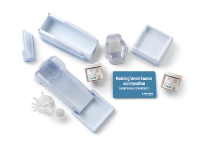
Kit #442Stream Erosion Kit
Student groups use a specially engineered Lab-Aids river model to investigate the dynamics of erosion and deposition of sediments. Students observe, describe, and interpret the erosional and depositional patterns created when “rain” falls over a non-level sand surface. Common features created and described include stream channels, canyons, meanders, sand bars, and deltas....
$236.00 View Details -
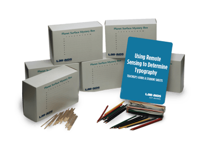
Kit #444SRemote Sensing and Topography
Students are introduced to remote sensing as a means to obtain information about things that are hard to observe directly. They perform a hands-on activity that allows them to create diagrams showing the shape of concealed landforms. Each student group collects data that allows them to construct a line graph showing a profile of...
$240.10 View Details